Deep learning model classifies natural habitats from ground-level photographs with strong accuracy
By
Mahdis Tourian ,
Summary
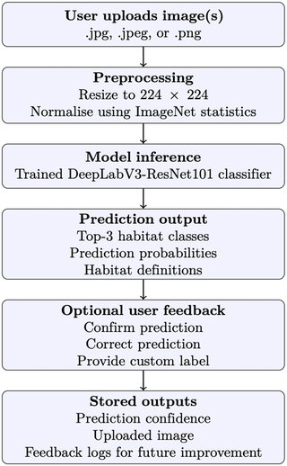
This paper presents a methodology for classifying terrestrial habitats using ground-level photographs and deep learning, rather than traditional satellite imagery. Developed in collaboration with Natural England, the study uses a DeepLabV3-ResNet101 architecture to classify images into 16 habitat classes following the 'Living England' framework. The model achieved a mean F1-score of 0.63 across all classes, with high performance (above 0.87) for visually distinct habitats like Bare Sand and Coniferous Woodland, and lower performance for visually mixed classes. The approach supports scalable, robust habitat classification and includes a web application for practitioners to upload and classify images.
Source
 bskyDeep learning model classifies natural habitats from ground-level photographs with strong accuracyplos.io
Key quotes
· 5 pulledAccurate classification of terrestrial habitats is critical for biodiversity conservation, ecological monitoring, and land use planning.
This approach supports robust, scalable habitat classification based on balanced and well-prepared training data.
Across all folds, the model achieved a mean F1-score of 0.63, with some habitat classes such as Bare Sand (BS) and Coniferous Woodland (CW) reaching values above 0.87.
Ground-level imagery is easily obtained and accurate computational methods for habitat classification based on such data have many potential applications.
To support use by practitioners, a simple web application is also provided that allows classification of uploaded images using the trained model.
You might also wanna read


Field Testing Satellite-Based Bramble Detection for Hedgehog Habitat Mapping
Researchers conducted field testing of a machine learning model designed to identify bramble habitats from satellite data, specifically for

DatBench: A New Framework for More Faithful and Efficient Vision-Language Model Evaluation
The article introduces DatBench, a new evaluation framework for vision-language models (VLMs) that addresses critical issues in current eval
Theoretical Foundations of Deep Learning
 clcoding.com·8d ago
Deep Neural Networks Converge to Universal Low-Dimensional Subspaces Across Diverse Tasks
This research article presents empirical evidence that deep neural networks trained on diverse tasks converge to remarkably similar low-dime

Machine Learning Validates Unrecognized Transient Astronomical Phenomena in Historical Observatory Images
This research paper uses machine learning to validate the existence of previously unrecognized transient astronomical phenomena in historica

Comparative Analysis of State-of-the-Art Generative AI Image Models
This article presents a comparative analysis of state-of-the-art generative AI image models, evaluating their performance on specific prompt
 genai-showdown.specr.net·7mo ago
Comments
Sign in to join the conversation.
No comments yet. Be the first.