M6.7 earthquake strikes Central Sulawesi, Indonesia; over 700,000 exposed to severe shaking
By
Kyle Bradley, Judith A Hubbard
Summary
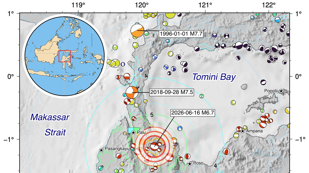
A magnitude 6.7 earthquake struck Central Sulawesi, Indonesia on June 16, 2026 at 11:27 local time. The USGS estimates over 700,000 people experienced very strong to severe shaking (intensity VII-VIII), with casualties likely. News agencies report structural damage. The event is a normal-mechanism earthquake east of the 2008 M7.5 strike-slip rupture.
Source
 bskyM6.7 earthquake strikes Central Sulawesi, Indonesia; over 700,000 exposed to severe shakingearthquakeinsights.substack.com
Key quotes
· 2 pulledThe USGS PAGER estimates that over 700,000 people experienced shaking of intensity VII-VIII (very strong to severe), and that casualties are likely.
News agencies are reporting that some structures have
You might also wanna read


Magnitude-7.0 earthquake strikes remote area near Alaska-Yukon border
A magnitude-7.0 earthquake struck in a remote area near the Alaska-Yukon border on Saturday, with no tsunami warning issued and no immediate
 apnews.com·6mo ago
Seismic wave from 2011 Tohoku earthquake shifted Japan 5 millimeters eastward
Fifteen minutes after the magnitude-9 Tohoku earthquake on March 11, 2011, a powerful seismic wave traveled 5,800 kilometers to the Earth's
 newscientist.com·2h ago
Seismic wave from 2011 Japan earthquake bounced off Earth's core, shifting the country eastward
A 2011 earthquake in Japan triggered a seismic wave that bounced off Earth's core and returned, causing the entire country to shift a few mi
 sciencenews.org·14h ago
Seismic wave from 2011 Japan earthquake bounced off Earth's core, shifting the country eastward
A 2011 earthquake in Japan triggered a seismic wave that bounced off Earth's core and returned, causing the entire country to shift a few mi
sciencenews.org·14h agoFirst-Ever Footage of Earthquake Causing 2.5-Meter Ground Slip
A security camera in Myanmar captured the first-ever footage of the Earth's surface shifting 2.5 meters sideways during a magnitude 7.7 eart
First-Ever Video of Earthquake Fault in Motion Revealed Through CCTV Footage
CCTV footage captured in Myanmar in March shows the first-ever video of an earthquake fault in motion, revealing a curved path of the fault

Klaxon: A Real-Time Global Earthquake & Emergency Event Map Powered by USGS Data
Klaxon is a real-time global earthquake and emergency event map built on USGS data. It features a tectonic plate overlay, PAGER/MMI flags, a
Comments
Sign in to join the conversation.
No comments yet. Be the first.